


DroneDeploy - Mapping for DJI
Description of DroneDeploy - Mapping for DJI
DroneDeploy is a cloud-based software platform designed for commercial drones, offering users powerful tools for aerial data collection and analysis. This application is particularly beneficial for industries such as construction, agriculture, surveying, and mining, enabling users to harness the capabilities of their DJI drones. Available for the Android platform, users can easily download DroneDeploy to access its features for automated mapping and data processing.
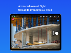
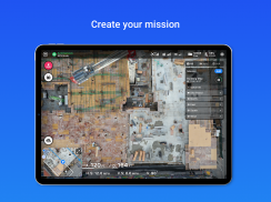
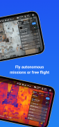
With DroneDeploy, users can fly their DJI drones autonomously with just a couple of taps on their Android devices. The app simplifies the process of creating flight plans, allowing for seamless automation of takeoff, flight, image capture, and landing. This feature is valuable for users looking to efficiently map large areas without needing constant manual control.
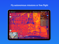
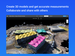
Data processing is another significant aspect of DroneDeploy. Users can quickly process imagery captured by their drones to generate high-resolution maps and 3D models. The app supports various types of mapping, including orthomosaics, NDVI (Normalized Difference Vegetation Index) maps, and digital elevation models, enabling thorough analysis of the captured data. The ability to measure elevation, distance, and area enhances the app's usability for professionals in multiple fields, while volume measurement is available for paid subscribers.
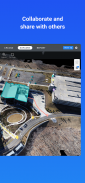
Collaboration is facilitated within DroneDeploy, allowing users to share maps and comments with team members. This feature is particularly useful for project coordination, ensuring that all stakeholders have access to the same aerial data and insights. The app also includes in-app support for paid customers, providing assistance when needed.
The app's compatibility with DJI’s latest drone models, such as the Mavic 2 Pro, Phantom 4 Pro, and Matrice 200 series, expands its accessibility for drone operators. However, it is important to note that DroneDeploy is not compatible with the DJI Mavic Mini series, limiting its use for those who own that particular model.
In-field data analysis can be performed on any mobile device, allowing users to explore interactive maps and 3D models directly from their Android devices. This flexibility means that users can assess their data in real time, making quick decisions based on the information gathered during flights.
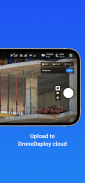
For users who prefer to process their imagery on a larger screen, DroneDeploy offers an option to upload images from the drone’s SD card to its web platform. This capability allows for the creation of high-accuracy maps and models through the processing of ground control points. The data can then be exported in various formats, catering to the diverse needs of professionals across different industries.
The app also features a robust App Market, providing access to over 80 additional applications designed to extend functionality and enhance data analysis. Users can select and integrate these tools based on their specific requirements, further tailoring DroneDeploy to their workflow.
DroneDeploy's automated mapping capabilities make it suitable for both newcomers and seasoned professionals. The straightforward interface guides users through the mapping process, while advanced features cater to experienced operators looking for in-depth analysis and control. The ability to easily switch between automated flights and manual control ensures that users can adapt to changing conditions in the field.
Users can benefit from the live streaming feature, which allows for First Person View (FPV) during flights. This capability enhances situational awareness, allowing operators to monitor their drone's environment in real time. Additionally, the option to disable auto-flight and regain manual control with a single tap provides an extra layer of safety and flexibility.
The app's design emphasizes ease of use, ensuring that even those with minimal experience can quickly learn to navigate its features. With a focus on accessibility, DroneDeploy democratizes aerial data collection, making it possible for users from various fields to leverage drone technology for their specific applications.
By integrating automation, data analysis, and collaboration, DroneDeploy stands out as a comprehensive solution for drone operators. The combination of high-resolution mapping capabilities, real-time data access, and extensive app integration provides a powerful toolset for maximizing the potential of aerial imagery.
As professionals continue to recognize the value of drone technology in their industries, applications like DroneDeploy will play a crucial role in streamlining workflows and enhancing productivity. This app not only simplifies the mapping process but also fosters collaboration and data sharing, making it an essential resource for those involved in aerial imaging and analysis.
For further information and to engage with the DroneDeploy community, users can visit the official forum at http://forum.dronedeploy.com.
DroneDeploy - Mapping for DJI - Version 5.48.0
(23-09-2024)DroneDeploy - Mapping for DJI - APK Information
APK Version: 5.48.0Package: com.dronedeploy.betaLatest Version of DroneDeploy - Mapping for DJI
Other versions


 4.33
4.33 3.67
3.67Apps in the same category


You may also like...


